Search Issues
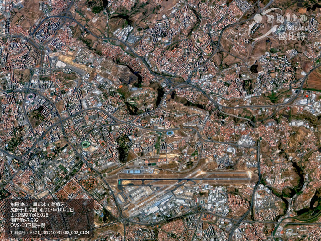
Zhuhai Orbita’s satellites can deliver Earth observation data at a 10-metre spectral resolution
Founded in 2000, Zhuhai Orbita Aerospace Science and Technology Co. Ltd. is a listed space technology manufacturer specialising in space electronics, satellite big data and artificial intelligence.
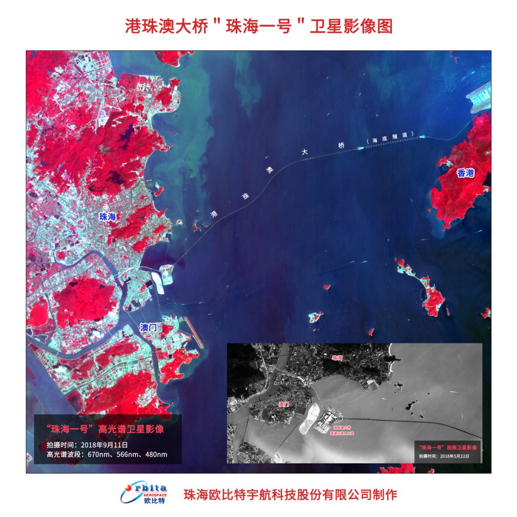
In April 2018, four hyperspectral satellites arrived 500-kilometers high from Earth on the back of the Long March 11 rocket. The four satellites are part of the Zhuhai Orbita’s aggressive “ZHUHAI NO. 1 satellite Constellation” plan to launch a constellation of nanosatellites into outer space.
“Orbita’s Satellite Constellation is the first ever to deliver near real-time observation to the Earth,” Dr. Yan Jun, President of Zhuhai Orbita, told Macao Image. “For example, we scan the globe once every five days, involving data flows in the order of terabytes per day.”
The satellites can deliver Earth observation data at a 10-metre spectral resolution.
With the aid of big data and Geographic Information System (GIS) mapping technologies, such data can be applied to a wide range of industries – agriculture, fishery, water resources, the atmospheric environment, as well as the monitoring of water and marine environments, mineral resources, forest coverage, disasters and rescue, urban planning and traffic.
In 2017, the group invested approximately RMB20 million (US$2.87 million) to set up a sister company in Macao – Macao Aerospace Technology Ltd. – to expand its satellite data business. The aim is to ride on Macao’s ability to connect China and Portuguese-speaking Countries as a commercial co-operation platform and provide satellite data analysis around the world.

“Orbita’s Satellite Constellation is the first ever to deliver near real-time observation to the Earth.” Dr. Yan Jun, President of Zhuhai Orbita
Satellite data technology marches in
Macao Aerospace Technology is bringing Orbita’s underground utilities survey system to Macao. The system infuses earth observation data with the information collected by onsite personnel using traditional mapping tools, such as pipe locators, geological radars and other underground utilities surveying and mapping tools, to set up a precise and comprehensive database of underground utilities.
Harnessing earth observation data and imagery collected by Orbita’s satellites, the system aims to enhance accuracy and coverage of the mapping of underground utilities including pipes, conduits and cables that supply power, telecommunication and water for a city.
“The database not only reveals whether the underground facilities meet national standards”, said Kingston Wang, Deputy General Manager at Macao Aerospace Technology. “It also detects underlying problems to reduce losses in revenue and to enhance safety.”
“The system shows the depth of the pipes, conduits and cables, the space between them as well as their functions,” he added.
“The lack of a comprehensive and accurate underground utility database would hinder the progress of urban planning, design, construction and also management, causing significant financial losses and a threat to safety,” he cautioned, adding the database also helps prevent accidents in future road excavation or penetration constructions.
The company is pitching the system to Macao authorities. He urged caution on a city-wide mapping system to be deployed in Macao for it is an integral part in urban development.
“The underground pipe, conduit and cable network of a city is like blood vines in the human body. A single malfunction may create a domino effect. The mapping should cover every single road in a city,” he noted.
Survey systems like these are already being implemented in multiple provinces throughout Mainland China by Zhuhai Orbita.
Mr Wang added that the system also assists in monitoring land reclamation by measuring residual settlement. “Land reclamation is a big topic in Macao. A mapping system using earth observation imagery enables the prediction of residual settlement in order to ensure greater land reclamation safety,” he said.
Additional use of such databases includes the detection and monitoring of pollution in the sea which would benefit the fishery industry, as well as identify unlawful occupation of land.
Macao Aerospace Technology is bringing Orbita’s underground utilities survey system to Macao
AI in use
Artificial intelligence (AI) has been widely adopted across a variety of industries in the world, and now it’s venturing well beyond it.
“I believe that AI will play a very important role in future space explorations,” stated Dr. Yan.
Although still in its infancy, AI’s growing role in space is a force to be reckoned with. It is already being used in spacecraft to dodge debris and transmit data.
In light of this, the company has poured RMB50 million into establishing a research institute focusing on AI chip architecture, AI algorithms, AI information processing and analysis mechanism for satellite data.
“We are very confident that the achievements of this research institute will benefit all walks of life,” said Dr. Yan, adding the team is working with a number of research institutes and universities in Macao.
The development of a new AI processor chip is also underway for the next generation of commercial satellites and space shuttles.


 mapping technologies, such data can be applied to a wide range of industries – agriculture, fishery, water resources, the atmospheric environment, as well as the monitoring of water and marine environments, mineral resources, forest coverage, disasters and rescue, urban planning and traffic.
In 2017, the group invested approximately RMB20 million (US$2.87 million) to set up a sister company in Macao – Macao Aerospace Technology Ltd. – to expand its satellite data business. The aim is to ride on Macao’s ability to connect China and Portuguese-speaking Countries as a commercial co-operation platform and provide satellite data analysis around the world.
[caption id="attachment_240481" align="alignnone" width="1024"]<img class="wp-image-240481 size-large" src="https://www.ipim.gov.mo/wp-content/uploads/2018/12/MI72-P35-1024x686.jpg" alt="MI72-P35" width="1024" height="686" /> "Orbita’s Satellite Constellation is the first ever to deliver near real-time observation to the Earth." Dr. Yan Jun, President of Zhuhai Orbita[/caption]
<strong>Satellite data technology marches in</strong>
Macao Aerospace Technology is bringing Orbita’s underground utilities survey system to Macao. The system infuses earth observation data with the information collected by onsite personnel using traditional mapping tools, such as pipe locators, geological radars and other underground utilities surveying and mapping tools, to set up a precise and comprehensive database of underground utilities.
Harnessing earth observation data and imagery collected by Orbita’s satellites, the system aims to enhance accuracy and coverage of the mapping of underground utilities including pipes, conduits and cables that supply power, telecommunication and water for a city.
“The database not only reveals whether the underground facilities meet national standards”, said Kingston Wang, Deputy General Manager at Macao Aerospace Technology. “It also detects underlying problems to reduce losses in revenue and to enhance safety.”
“The system shows the depth of the pipes, conduits and cables, the space between them as well as their functions,” he added.
“The lack of a comprehensive and accurate underground utility database would hinder the progress of urban planning, design, construction and also management, causing significant financial losses and a threat to safety,” he cautioned, adding the database also helps prevent accidents in future road excavation or penetration constructions.
The company is pitching the system to Macao authorities. He urged caution on a city-wide mapping system to be deployed in Macao for it is an integral part in urban development.
“The underground pipe, conduit and cable network of a city is like blood vines in the human body. A single malfunction may create a domino effect. The mapping should cover every single road in a city,” he noted.
Survey systems like these are already being implemented in multiple provinces throughout Mainland China by Zhuhai Orbita.
Mr Wang added that the system also assists in monitoring land reclamation by measuring residual settlement. “Land reclamation is a big topic in Macao. A mapping system using earth observation imagery enables the prediction of residual settlement in order to ensure greater land reclamation safety,” he said.
Additional use of such databases includes the detection and monitoring of pollution in the sea which would benefit the fishery industry, as well as identify unlawful occupation of land.
[caption id="attachment_240482" align="alignnone" width="1024"]<img class="wp-image-240482 size-large" src="https://www.ipim.gov.mo/wp-content/uploads/2018/12/MI72-P36-1024x1024.jpg" alt="MI72-P36" width="1024" height="1024" /> Macao Aerospace Technology is bringing Orbita’s underground utilities survey system to Macao[/caption]
<strong>AI in use</strong>
Artificial intelligence (AI) has been widely adopted across a variety of industries in the world, and now it’s venturing well beyond it.
“I believe that AI will play a very important role in future space explorations,” stated Dr. Yan.
Although still in its infancy, AI’s growing role in space is a force to be reckoned with. It is already being used in spacecraft to dodge debris and transmit data.
In light of this, the company has poured RMB50 million into establishing a research institute focusing on AI chip architecture, AI algorithms, AI information processing and analysis mechanism for satellite data.
“We are very confident that the achievements of this research institute will benefit all walks of life,” said Dr. Yan, adding the team is working with a number of research institutes and universities in Macao.
The development of a new AI processor chip is also underway for the next generation of commercial satellites and space shuttles.%0D%0DReference Link : %0Dhttps://www.ipim.gov.mo/en/publication/issue-72-oct-2018/business/zhuhai-orbita-leads-satellite-data-technology-to-macao/)